Introduction
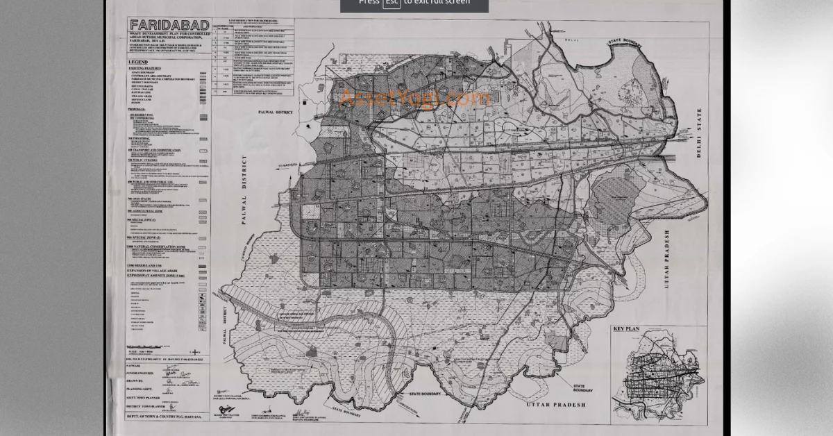
The Haryana Government’s Town and Country Planning Department has published the Draft Development Plan 2031 A.D. for the controlled areas outside Municipal Corporation, Faridabad. This comprehensive plan aims to guide the sustainable urban development of Faridabad, a rapidly growing city in the National Capital Region (NCR) of India. The draft plan, which is open for public suggestions and objections, encompasses a total area of 45,687 hectares and is designed to accommodate a projected population of 38.86 lakh by 2031.
Background and Context
Faridabad, founded in 1607 A.D., is one of the most populated and industrialized cities in Haryana. Situated along the Delhi-Mathura road (NH-44) and well-connected by rail and road, Faridabad is a major industrial hub and a recommended Metro town in the NCR. The city has witnessed significant growth over the past few decades, with its population increasing from 59,039 in 1961 to 14,38,855 in 2011.
The Draft Development Plan 2031 A.D. builds upon the previous development plans, including the Final Development Plan of Faridabad-Ballabgarh Complex 2011 A.D., which had proposals for urbanization up to the revenue estate of village Jharsently in the south. The current draft plan takes into account the anticipated implementation of various infrastructure projects such as the Metro Rail, Dedicated Freight Corridor, and Eastern Peripheral Expressway, which are expected to further boost the city’s growth.
Key Highlights of the Draft Development Plan 2031 A.D.
1. Land Use Distribution
The draft plan proposes a balanced distribution of land uses across the 34,368 hectares of urbanizable area to accommodate the projected population of 38.86 lakh by 2031. The land use breakup is as follows:
- Residential: 14,328 hectares (41.69%)
- Commercial: 2,069 hectares (6.02%)
- Industrial: 6,179 hectares (17.98%)
- Transport & Communication: 4,020 hectares (11.70%)
- Public Utility: 638 hectares (1.86%)
- Public & Semi-Public Uses: 1,299 hectares (3.78%)
- Open Spaces, Parks & Green Belts: 5,314 hectares (15.46%)
- Special Zone: 448 hectares (1.30%)
- Mixed Land Use: 73 hectares (0.21%)
2. Residential Development
The draft plan allocates 14,328 hectares for residential development, with an average residential density of 271 persons per hectare (PPH). The proposed residential sectors will have a density of 300 PPH, while sectors 119, 143, and 146, adjoining the industrial sectors, will have a higher density of 600 PPH to accommodate group housing projects for industrial workers. Eight pockets of 25 hectares each have been reserved for high-density development of 1,125 PPH to provide housing for low and medium-income groups.
3. Commercial Development
A total of 2,069 hectares has been proposed for commercial use, with a focus on linear development along major roads to curb the tendency of converting residential areas into commercial use. The plan also designates sectors 100, 120, and 154 as city centers.
Unlock Your Dream Home Today!
Get personalized real estate insights delivered straight to your inbox.
4. Industrial Growth
Recognizing Faridabad’s role as a major industrial center, the draft plan allots 6,179 hectares for industrial development. The Haryana State Industrial and Infrastructure Development Corporation (HSIIDC) has already developed an Industrial Model Township (IMT) in sectors 66, 67, 68, and 69, situated east of the Agra Canal.
5. Transport and Connectivity
The draft plan emphasizes the development of a robust transport network to support the city’s growth. Key proposals include:
- Widening and strengthening of existing bridges on Agra and Gurgaon Canals
- Construction of new bridges on sector-dividing roads crossing the canals
- Development of a 60-meter wide bypass road to relieve congestion on the Delhi-Mathura Road (NH-44)
- Proposed 75-meter and 90-meter wide roads parallel to NH-44 to bypass the city
- 100-meter wide Eastern Peripheral Expressway with 100-meter wide green belts on both sides
- Metro connectivity along Delhi-Mathura Road up to Ballabgarh and along the bypass road and 75-meter wide road
- Regional Rapid Transit System along the existing Delhi-Mathura Railway line
- Inner Regional Orbital Rail Corridor (IRORC) to connect Sonepat-Jhajjar-Gurgaon-Faridabad-Dadri-Meerut-Baghpat-Sonepat
- Orbital Rail Corridor along the Eastern Peripheral Expressway with a 50-meter width
- Integrated hierarchy of road networks with varying right-of-way widths
6. Public Utilities and Services
The draft plan earmarks 638 hectares for public utility purposes, including water supply installations, sewage treatment plants, electric power plants, and substations. Efforts will be made to recycle and reuse wastewater, and treated water will be utilized for reviving the Badkhal lake. The plan also proposes suitable sites for solid waste management, disposal of silt/debris, medical waste, and carcasses.
7. Public and Semi-Public Uses
An area of 1,299 hectares has been proposed for public and semi-public uses in a linear pattern along major roads. The plan includes provisions for town-level facilities such as colleges and hospitals, considering the projected population of 38.86 lakh.
8. Open Spaces and Green Belts
The draft plan allocates 5,314 hectares for open spaces, parks, and green belts. Major open spaces are proposed along major roads, the Dedicated Freight Corridor, and between industrial and residential areas. The plan also includes provisions for town-level green areas, a golf course, and a central park.
9. Special Zones and Mixed Land Use
Two special zones have been proposed in the draft plan. Special Zone-1 includes institutions, offices, and recreational buildings with ancillary residential and commercial uses, while Special Zone-2 is designated for residential and commercial uses. The plan also identifies areas under mixed land use, allowing for a combination of residential, commercial, and industrial activities.
10. Natural Conservation Zone
The draft plan designates the area on the western side of the western peripheral road, falling mostly under the Aravalli ranges, as a Natural Conservation Zone. A 500-meter wide belt along the Yamuna River has also been proposed under this zone. Permissible activities in this zone include agriculture, horticulture, pisciculture, social forestry, and regional recreational activities with construction not exceeding 0.5% of the area.
11. Environmental Concerns and Heritage Conservation
The draft plan emphasizes the need for environmental clearance for project execution and adherence to
the restrictions applicable to eco-sensitive zones and areas notified under the Punjab Land Preservation Act, 1900. The plan also highlights the importance of protecting monuments, heritage sites, and areas of aesthetic, sentimental, or historic value.
12. Zoning Regulations and Development Controls
The draft plan includes a set of zoning regulations (Annexure B) to govern land use changes and development standards. These regulations provide a legal framework for the proposals outlined in the plan and ensure the preparation of detailed sector plans for each sector to guide development and enforce proper control.
Conclusion
The Draft Development Plan 2031 A.D. for the controlled areas outside Municipal Corporation, Faridabad, presents a comprehensive vision for the sustainable urban growth of the city. By proposing a balanced distribution of land uses, enhancing connectivity, and prioritizing environmental conservation, the plan aims to transform Faridabad into a thriving residential, commercial, and industrial hub while ensuring a high quality of life for its residents.
The success of the plan will depend on the effective collaboration among various stakeholders, including the government, development authorities, private sector, and citizens. The public’s participation in the planning process, through suggestions and objections, is crucial to refine the plan and ensure that it meets the needs and aspirations of the community.
As Faridabad continues to grow and evolve, the implementation of the Draft Development Plan 2031 A.D. will play a pivotal role in shaping the city’s future. By adhering to the principles of sustainable development, promoting inclusive growth, and leveraging the city’s strategic location and industrial prowess, Faridabad can emerge as a model for urban development in the region and beyond.
Reference Document – Development Plan
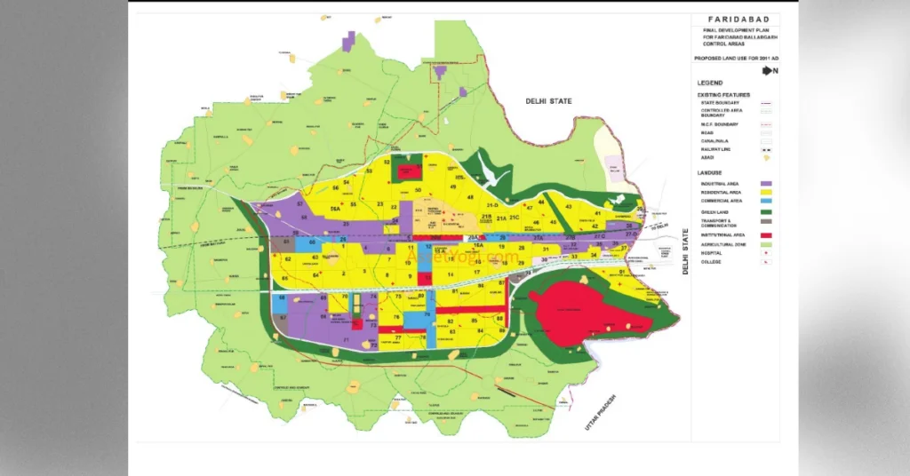
Map
The Faridabad Master Plan 2031 is a comprehensive development plan published by the Haryana Government's Town and Country Planning Department, aimed at guiding sustainable urban development in Faridabad, projected to accommodate a population of 38.86 lakh by 2031.
The plan encompasses a total area of 45,687 hectares, focusing on controlled areas outside the Municipal Corporation of Faridabad.
The land use distribution includes 41.69% residential, 6.02% commercial, 17.98% industrial, 11.70% transport & communication, 1.86% public utility, 3.78% public & semi-public uses, 15.46% open spaces, and 1.30% special zones.
The plan allocates 14,328 hectares for residential development with various densities, including a high-density development area for low and medium-income groups.
The plan emphasizes developing a robust transport network, including widening existing roads, constructing new bridges, and establishing metro connectivity along major roads.
The plan stresses the need for environmental clearance, adherence to eco-sensitive zone regulations, and the protection of heritage sites and natural conservation zones.
The plan earmarks 638 hectares for public utilities, including water supply, sewage treatment, electric power plants, and solid waste management facilities.
Yes, the plan includes two special zones designated for institutions, offices, and recreational buildings, as well as areas for mixed land use.
Public participation is crucial for refining the plan, as the government encourages citizens to provide suggestions and objections to ensure the plan meets community needs.
The success will depend on effective collaboration among stakeholders, including government, development authorities, and citizens, alongside the implementation of sustainable development principles.
DISCLAIMER
The information provided on this website is for general informational purposes only. While we strive to keep the content up-to-date and accurate, we make no representations or warranties of any kind, express or implied, about the completeness, accuracy, reliability, suitability, or availability of the information, products, services, or related graphics contained on this website.
In no event will we be liable for any loss or damage including without limitation, indirect or consequential loss or damage, or any loss or damage whatsoever arising from loss of data or profits arising out of, or in connection with, the use of this website.
Real Estate Investment Risks
Real estate investments involve significant risks and market volatility. Property values, rental rates, and market conditions can fluctuate. Past performance is not indicative of future results.
Before Making Real Estate Decisions
Before making any real estate decision, we strongly advise you to:
- Conduct thorough due diligence
- Consult with qualified legal, financial, and real estate professionals
- Carefully review all relevant documents and contracts
- Consider your personal financial situation and investment goals
This website does not provide legal, financial, or investment advice. All content is for informational purposes only and should not be construed as professional advice or recommendations.
By using this website, you acknowledge and agree to these terms. We reserve the right to modify this disclaimer at any time without notice.

