Introduction
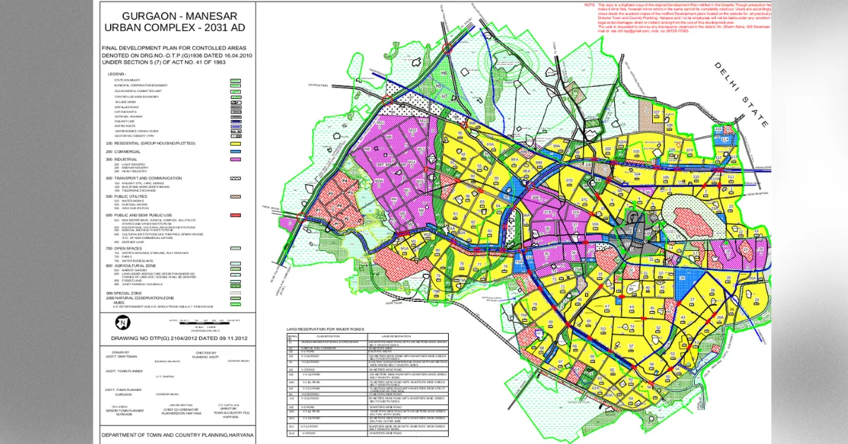
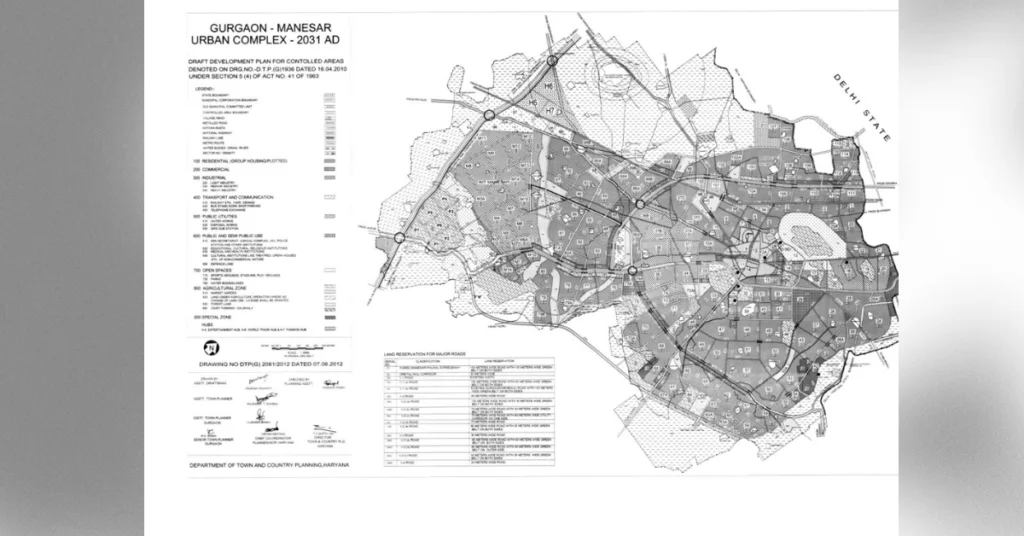
The Draft Development Plan 2031 AD for Gurgaon-Manesar Urban Complex, published by the Haryana Government’s Town and Country Planning Department, is a comprehensive blueprint for the sustainable growth of this rapidly developing region. The plan, which is open for public suggestions and objections, aims to guide the urban development of Gurgaon-Manesar Urban Complex, a key area in the National Capital Region (NCR) known for its thriving automobile industries, modern commercial malls, and software development centers.
Background and Context
Gurgaon-Manesar Urban Complex has emerged as a global hub for business and technology, attracting multinational companies across various sectors, including automobiles, software development, and services. The establishment of Maruti Suzuki, in collaboration with Japan’s Suzuki Company, in 1972 marked a turning point in the region’s growth trajectory. Since then, numerous international companies have set up operations in the area, drawn by its strategic location, proximity to the Indira Gandhi International Airport, and access to a skilled workforce.
The Haryana Urban Development Authority (HUDA) and licensed colonizers in the private sector have played a crucial role in the planned development of Gurgaon-Manesar Urban Complex. Together, they have developed approximately 8,000 hectares of land for residential, commercial, institutional, and industrial purposes to meet the growing demands of the public.
Projected Population and Land Use
The Draft Development Plan 2031 AD has been designed to accommodate a projected population of 42.50 lakh by 2031. The total urbanizable area proposed in the plan is 22,957 hectares, which, combined with the existing developed areas, village abadis, and the existing town, would cater to the needs of the projected population.
The extent of various land uses proposed in the Development Plan is as follows:
| Land Use | Area (hectares) |
|---|---|
| Residential | 16,010 |
| Commercial | 1,616 |
| Industrial | 4,613 |
| Transport and Communication | 4,420 |
| Public Utilities | 626 |
| Public and Semi-Public Use | 2,035 |
| Open Spaces | 2,775 |
| Special Zone | 114 |
| Defence Land | 633 |
| Total Land | 32,842 |
| Existing Town | 406 |
| Village Abadis | 478 |
| Grand Total | 33,726 |
Residential Development
To cater to the projected population of 42.50 lakh, an area of 16,010 hectares has been reserved for residential purposes. HUDA and licensed colonizers have already developed residential areas of 8,000 hectares in various sectors, which would accommodate a population of 20.00 lakh. The existing town and village abadis within the urbanizable area are also expected to house 2 lakh people. The additional residential area proposed in the Development Plan would cater to the housing needs of the remaining 20.50 lakh projected population. The residential areas will be developed based on the neighborhood concept, with provisions for community facilities and services within the sectors at an average net residential density of 250 persons per hectare.
Unlock Your Dream Home Today!
Get personalized real estate insights delivered straight to your inbox.
Commercial Development
The Development Plan has reserved 1,616 hectares of land for commercial purposes, of which HUDA has already developed 480 hectares. The new commercial areas will be developed as large commercial malls and corporate commercial complexes. Additionally, commercial belts with a width of 200 meters have been provided along selected roads to cater to the needs of the surrounding areas. Approximately 48.50 hectares of land has been reserved along the Delhi-Rewari Railway line in sector 99A for wholesale trading of building materials, grains, fruits, and vegetables, which shall be developed exclusively by the Government or its agencies.
Industrial Development
To meet the growing demand for software industries, automobile industries, and other pollution-free hi-tech industries, an area of 4,613 hectares has been reserved for industrial use. The Haryana State Industrial Infrastructure Development Corporation (HSIIDC) and HUDA have already developed 1,246 hectares in the complex. New industrial areas have been proposed along the expressway adjacent to the Industrial Model Township (IMT) Manesar.
Transport and Communication
The Development Plan proposes several new road links to enhance connectivity between Gurgaon-Manesar Urban Complex, Delhi Metropolitan City, and the upcoming Sohna town. These include:
- 90-meter wide road link between Vasant Kunj in Delhi and Mehrauli road in Gurgaon
- 90-meter wide road link from Andheria Mor in Delhi to Gurgaon-Faridabad road in Gurgaon through Mandi and Gual Pahari
- 150-meter wide road link between Dwarka residential complex in Delhi and Gurgaon at National Highway number 8 before Toll Plaza towards Gurgaon
- 90-meter wide road link from the junction of sector 63A/64 with V3(b) road of Gurgaon-Manesar Urban Complex-2031 AD to the sector dividing road of sector 30/31 of Development Plan of Sohna-2031 AD
The sector dividing roads in the new urbanizable area have been proposed with widths of 75 meters and 60 meters. Transport Nagars and container depots have been proposed adjoining the Garhi Harsaru Railway Station on the Delhi-Rewari Railway line, along with a pocket of 45 hectares of land for idle parking.
An additional Mass Rapid Transit System Corridor has been proposed along the 150-meter wide northern link road to Delhi, extending from “Dwarka” in Delhi up to the proposed Inter State Bus Terminal near village Kherki Duala. Another Mass Rapid Transit System Corridor has been proposed along Mehrauli road and a 60-meter wide road of sector 28-29, which is planned to be extended up to the 90-meter link road to Delhi via Gual Pahari and further to the Inter State Bus Terminal, completing the Mass Rapid Transit System loop and extending to Manesar.
Public Utilities and Services
Approximately 626 hectares of land have been proposed for public utilities in sectors 37D, 99A, 100, 101, and 107 to meet the future needs of the projected population. Electric lines up to 66 KV in the urbanizable
area shall be laid underground.
Public and Semi-Public Uses
To cater to the institutional demand of the 42.50 lakh population, an area of 2,035 hectares has been proposed for public and semi-public uses, of which HUDA has already developed 135 hectares. The proposed 200-meter wide institutional belt towards the south of the 60-meter outer periphery V-3(b) road will allow for the development of Government and semi-Government offices. An area of 215 hectares of land in sector 68 has been reserved for a university, which shall be exclusively set up by the Government.
Open Spaces and Green Areas
The Development Plan has made provisions for open spaces and green areas to enhance the quality of life for the residents. A 900-meter wide strip of land around the ammunition depot has been kept free from urbanization under the Works of Defence Act, 1903. Green belts have been proposed along the Delhi-Jaipur Highway, Railway line, and Badshahpur Nallah to accommodate any future widening requirements. Large open spaces have been proposed near villages Basai, Dhanwapur, Medawas, and flowing greens in other residential areas.
The open spaces in sector 72 and sector 72A have been earmarked for the creation of artificial water bodies, which will help in groundwater recharge, mitigate flash floods, and add to the aesthetic beauty of the area.
Special Zone and Agricultural Zone
The special zone in the Development Plan includes recreation and entertainment, commercial, group housing, and institutional uses. The agricultural zone, while allowing for essential building development such as the extension of existing villages contiguous to abadi deh and other ancillary facilities, will largely remain reserved for agricultural purposes. An area of approximately 50 hectares near village Dhankot, between the Gurgaon Water Supply (GWS) canal and the effluent channel, has been provided for dairy farming and Gaushala, where all the existing dairies in the city are proposed to be shifted in the future.
Zoning Regulations and Development Controls
The Draft Development Plan 2031 AD includes a set of zoning regulations (Annexure B) that provide the legal framework for land use changes and development standards. These regulations ensure that all land use changes and development activities are in accordance with the details shown in the sector plans, enabling the preparation of detailed sector plans for each sector to guide development and enforce proper control.
Conclusion
The Draft Development Plan 2031 AD for Gurgaon-Manesar Urban Complex is a comprehensive blueprint for the sustainable growth of this rapidly developing region. By proposing a well-balanced distribution of land uses, enhancing connectivity, and prioritizing the development of residential, commercial, and industrial areas, the plan aims to cater to the needs of the projected population of 42.50 lakh by 2031.
The success of the plan will largely depend on the effective collaboration between the government, development authorities, private sector, and the public. The active participation of citizens in the planning process, through suggestions and objections, is crucial to refine the plan and ensure that it meets the aspirations and requirements of the community.
As Gurgaon-Manesar Urban Complex continues to grow and evolve as a global hub for business and technology, the implementation of the Draft Development Plan 2031 AD will play a vital role in shaping its future. By adhering to the principles of sustainable development, promoting inclusive growth, and leveraging the region’s strategic location and industrial strengths, Gurgaon-Manesar Urban Complex can serve as a model for urban development in the NCR and beyond.
Reference Document
The Gurgaon Master Plan 2031 is a comprehensive blueprint published by the Haryana Government's Town and Country Planning Department aimed at guiding the sustainable urban development of the Gurgaon-Manesar Urban Complex, which is known for its rapid growth and thriving industries.
The Draft Development Plan 2031 AD is designed to accommodate a projected population of 42.50 lakh (4.25 million) by the year 2031.
An area of 16,010 hectares has been reserved for residential purposes to cater to the housing needs of the projected population.
The plan includes various land uses such as residential, commercial, industrial, transport and communication, public utilities, open spaces, and special zones.
The plan proposes several new road links and Mass Rapid Transit System Corridors to enhance connectivity between Gurgaon-Manesar, Delhi, and nearby towns, improving access and reducing congestion.
The Haryana Urban Development Authority (HUDA) and licensed private colonizers have collaborated to develop approximately 8,000 hectares of land for various purposes, contributing significantly to the planned development of the region.
The plan proposes about 626 hectares of land for public utilities to meet the future needs of the projected population, including underground electric lines for better infrastructure.
The plan includes provisions for open spaces and green areas to enhance residents' quality of life, including large open spaces and artificial water bodies for groundwater recharge and aesthetic improvement.
The plan is open for public suggestions and objections, which allows citizens to participate actively in refining the plan to meet community needs and aspirations.
The goal is to ensure balanced urban development, enhance connectivity, and cater to the needs of the projected population while promoting sustainable growth in the Gurgaon-Manesar Urban Complex.
DISCLAIMER
The information provided on this website is for general informational purposes only. While we strive to keep the content up-to-date and accurate, we make no representations or warranties of any kind, express or implied, about the completeness, accuracy, reliability, suitability, or availability of the information, products, services, or related graphics contained on this website.
In no event will we be liable for any loss or damage including without limitation, indirect or consequential loss or damage, or any loss or damage whatsoever arising from loss of data or profits arising out of, or in connection with, the use of this website.
Real Estate Investment Risks
Real estate investments involve significant risks and market volatility. Property values, rental rates, and market conditions can fluctuate. Past performance is not indicative of future results.
Before Making Real Estate Decisions
Before making any real estate decision, we strongly advise you to:
- Conduct thorough due diligence
- Consult with qualified legal, financial, and real estate professionals
- Carefully review all relevant documents and contracts
- Consider your personal financial situation and investment goals
This website does not provide legal, financial, or investment advice. All content is for informational purposes only and should not be construed as professional advice or recommendations.
By using this website, you acknowledge and agree to these terms. We reserve the right to modify this disclaimer at any time without notice.

